Tiberias district · depopulated 1948 · 2 min read
Lubya
لوبيا
Lubya, one of the largest villages of the Tiberias district, stood on a rocky hill over the Nazareth road and twice beat back attacks before its people fled the fall of Nazareth in July 1948. Its ruins lie under the JNF's Lavi and South Africa pine forests — a landscape of erasure that refugee historians have made one of the best-documented of any village.
See Lubya on the Atlas32.7759°N · 35.4293°E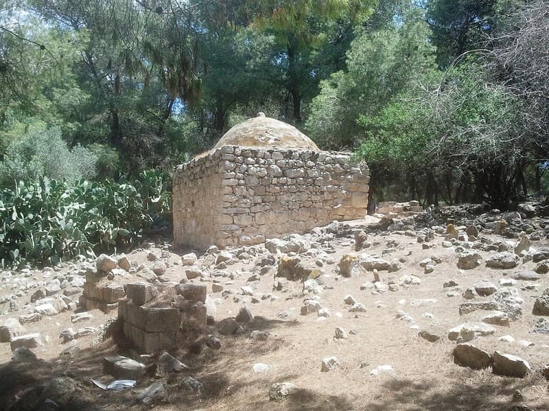
Lubya crowned a rectangular, rocky hill ten and a half kilometers southwest of Tiberias, overlooking the plain of Tur’an and split by the secondary road down to the Tiberias–Nazareth highway. The Crusaders knew it as Lubia; it was the hometown of the fifteenth-century Damascene scholar Abu Bakr al-Lubyani, and in 1743 Sulayman Pasha, the governor of Damascus, died there on his march against Zahir al-Umar. In 1596 it held 1,177 people; by 1945 it counted 2,350 — some 2,730 by 1948 — and its lands, nearly 40,000 dunums planted overwhelmingly with grain, were among the largest of any village in the district.
Lubya fought before it fell. An attack in early March 1948, meant to open the road between Tiberias and the settlement of Sejera, was repelled, and a second assault on 10–11 June, launched by the Golani Brigade under orders to expel the inhabitants, also failed. The end came with Operation Dekel: on 16 July word arrived that Nazareth had fallen, and that night most of the people left for Nimrin, ‘Aylabun, and on into Lebanon, leaving behind the village militia and some elderly. When an Israeli armored unit approached the next day, the militia withdrew; the village was shelled, some houses destroyed and others commandeered. ‘Lubiya fell without fighting,’ the History of the War of Independence records, ‘and the road to Tiberias was open to us.’ The remaining buildings were demolished in 1965.
The settlement of Lavi was founded on village lands in 1949, and the Jewish National Fund spread the Lavi pine forest over the western side of the site, with a second forest nearby planted in the name of South Africa — for which a group of South African Jewish activists publicly apologized to Lubya’s refugees at the site in 2015. The debris of the village lies buried under the trees; scattered wells, pomegranate and fig trees, and cactuses mark where houses stood, and the old road to the highway is still traceable. Lubya’s memory has been kept unusually well, in the writings and recordings of its own sons and daughters.
Sources
Cited works
3- palestineremembered.com — index(opens in a new tab)https://www.palestineremembered.com/Tiberias/Lubya/index.html
- zochrot.org — en(opens in a new tab)https://www.zochrot.org/villages/village_details/49244/en
- palquest.org — lubya(opens in a new tab)https://www.palquest.org/en/place/17086/lubya
Connected in the archive
8 connected records8 records elsewhere in the archive are linked to this one, each by a piece of evidence you can read below.
named in this record — 2 records
One record names the other. A pointer for reading, not a claim that they belong to each other.
- Nazarethالناصرة
Evidence — Inferred from the text — read the evidence: Lubya, one of the largest villages of the Tiberias district, stood on a rocky hill over the Nazareth road and twice beat back attacks before its people fled the fall of Nazareth in July 1948.
- Tiberiasطبريا
Evidence — Inferred from the text — read the evidence: Lubya crowned a rectangular, rocky hill ten and a half kilometers southwest of Tiberias, overlooking the plain of Tur'an and split by the secondary road down to the Tiberias–Nazareth highway.
names this place — 2 records
One record names the other. A pointer for reading, not a claim that they belong to each other.
- The Villages of the Galilee
Evidence — From a recorded field in this archive: One of the largest villages of the Tiberias district. Its ruins lie under a planted pine forest — the standard method for making a site unreadable.
- Nasir al-Dinناصر الدين
Evidence — Inferred from the text — read the evidence: Benny Morris writes that some non-combatants were apparently killed and some houses destroyed, and that most of the population fled to Lubya or to Tiberias, from where British troops moved them on to Lubya.
in the same district — 4 records
Filed near each other — the same Mandate district, or the same uncommon subject tags.
- Ghuwayr Abu Shushaغوير أبو شوشة
Evidence — From a recorded field in this archive: Both recorded in the Tiberias district.
- Hittinحطّين
Evidence — From a recorded field in this archive: Both recorded in the Tiberias district.
- Khirbat al-Wa'ra al-Sawda'خربة الوعرة السوداء
Evidence — From a recorded field in this archive: Both recorded in the Tiberias district.
- Samakhسمخ
Evidence — From a recorded field in this archive: Both recorded in the Tiberias district.
Cite this page
Every claim above carries its sources — citation is the point.
- Chicago
“Lubya.” Village Memory, FALASTEEN.AI. Accessed 22 August 2026. https://falasteen.ai/memory/lubya.- MLA
“Lubya.” Village Memory, FALASTEEN.AI, 2026, https://falasteen.ai/memory/lubya. Accessed 22 August 2026.- BibTeX
@misc{falasteen-lubya,
  title        = {Lubya},
  howpublished = {\url{https://falasteen.ai/memory/lubya}},
  organization = {FALASTEEN.AI — A Living Archive for Palestine},
  year         = {2026},
  note         = {Accessed 2026-08-22}
}