Jerusalem district · depopulated 1948 · 2 min read
Qaluniyya
قالونيا
Qaluniyya was a village on the Jerusalem–Jaffa highway whose name preserved the Roman Colonia founded on the ruins of Jewish Motza. Days after Deir Yassin, in April 1948, Haganah forces entered and blew up fifty of its houses; its ruins lie beside Motza, and Mevaseret Zion spreads over its lands.
See Qaluniyya on the Atlas31.7939°N · 35.1639°E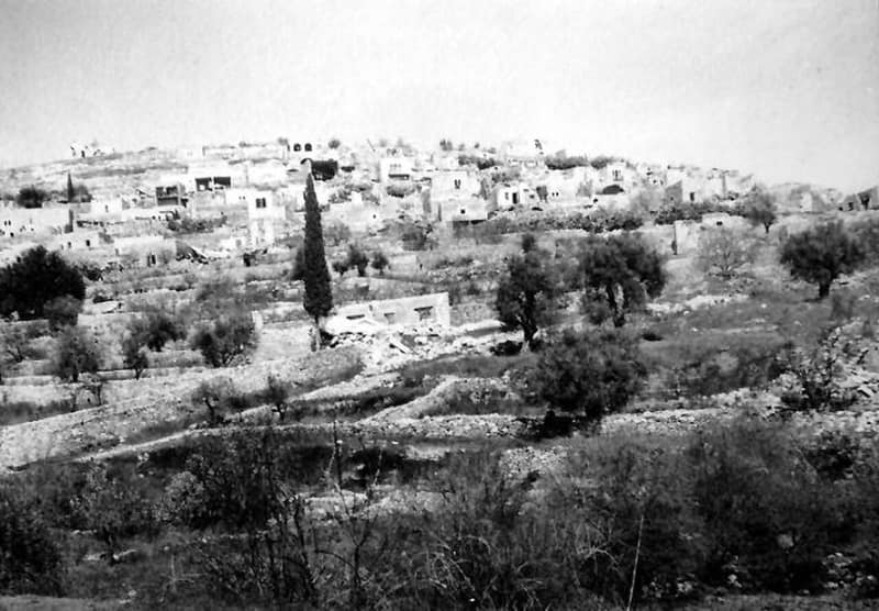
Qaluniyya stood on a mountain slope six kilometers west of Jerusalem, facing southwest over Wadi Qaluniyya, directly on the Jerusalem–Jaffa highway. Its name is a fossil of empire: after destroying the Jewish village of Motza in the First Jewish–Roman War, the emperor Vespasian settled 800 Roman veterans there in a colonia, and the word passed through Byzantine Greek into the Arabic Qalunya — one reason the site has been proposed as the Emmaus of the Gospel of Luke. In 1596 the village counted nineteen Muslim households, its revenues assigned to a waqf. Travelers in the 1880s found a moderate-sized village with a ‘modern’ restaurant and orange and lemon trees around the valley spring. In the 1890s Jews purchased some of its farmlands and established Motza, the first Jewish settlement outside Jerusalem’s walls; during the 1929 riots a nearby Jewish family, the Makleffs, was killed, and twelve men of Qaluniyya were charged but acquitted at trial. The 1945 survey counted 900 Muslims and 10 Christians in the village, beside 350 Jews in Motza, on 4,844 dunums.
The village sat just east of the battlefield of al-Qastal, astride the road that Arab forces were fighting to keep closed in the siege of Jewish Jerusalem. After the Haganah opened the road in Operation Nachshon, its forces entered Qaluniyya on 11 April 1948 — two days after the Deir Yassin massacre — and blew up fifty houses; the inhabitants had already been evacuated. Ilan Pappe counts Qaluniyya among four villages west of Jerusalem systematically destroyed in this fashion in the immediate wake of Deir Yassin, the others being Bayt Surik, Biddu, and Saris.
Ruins of the demolished village, covered in vegetation, still stand beside Motza just off the Jerusalem–Tel Aviv highway, and the town of Mevaseret Zion has expanded over part of Qaluniyya’s territory. In recent years archaeologists digging Tel Motza at the village’s edge uncovered an Iron Age temple, adding another layer to a site that has been continuously inhabited since the Early Bronze Age.
Sources
Cited works
3- zochrot.org — en(opens in a new tab)https://www.zochrot.org/villages/village_details/49444/en
- palquest.org — qalunya(opens in a new tab)https://www.palquest.org/en/place/17112/qalunya
- en.wikipedia.org — Qalunya(opens in a new tab)https://en.wikipedia.org/wiki/Qalunya
Connected in the archive
28 connected records28 records elsewhere in the archive are linked to this one, each by a piece of evidence you can read below.
named in this record — 3 records
One record names the other. A pointer for reading, not a claim that they belong to each other.
- Al-Qastalالقسطل
Evidence — Inferred from the text — read the evidence: The village sat just east of the battlefield of al-Qastal, astride the road that Arab forces were fighting to keep closed in the siege of Jewish Jerusalem.
- Deir Yassinدير ياسين
Evidence — Inferred from the text — read the evidence: After the Haganah opened the road in Operation Nachshon, its forces entered Qaluniyya on 11 April 1948 — two days after the Deir Yassin massacre — and blew up fifty houses; the inhabitants had already been evacuated.
- Jerusalemالقدس
Evidence — Inferred from the text — read the evidence: Qaluniyya stood on a mountain slope six kilometers west of Jerusalem, facing southwest over Wadi Qaluniyya, directly on the Jerusalem–Jaffa highway.
names this place — 1 record
One record names the other. A pointer for reading, not a claim that they belong to each other.
- ar-Ramالرام
Evidence — Inferred from the text — read the evidence: Its families are given by the local council as the Ramiyah, Ghazawnah, Khattab, as-Salaymah, Shweiki, Dweik, Abu Gharbiyah, Julani, Jaber, Ghaith, Jaradat, Matoor, an-Natsha, al-Qawasmi, al-Huseini and Abu 'Asab households — the Khattabs among families displaced from Qaluniya, the village west of Jerusalem emptied in 1948.
in the same district — 24 records
Filed near each other — the same Mandate district, or the same uncommon subject tags.
- 'Allarعَلاّر
Evidence — From a recorded field in this archive: Both recorded in the Jerusalem district.
- 'Artufعَرْتُوف
Evidence — From a recorded field in this archive: Both recorded in the Jerusalem district.
- 'Islinعِسْلِين
Evidence — From a recorded field in this archive: Both recorded in the Jerusalem district.
- Al-Malihaالمالِحَة
Evidence — From a recorded field in this archive: Both recorded in the Jerusalem district.
- Al-Qabuالقبو
Evidence — From a recorded field in this archive: Both recorded in the Jerusalem district.
- Al-Walajaالولجة
Evidence — From a recorded field in this archive: Both recorded in the Jerusalem district.
- and 18 more
Cite this page
Every claim above carries its sources — citation is the point.
- Chicago
“Qaluniyya.” Village Memory, FALASTEEN.AI. Accessed 22 August 2026. https://falasteen.ai/memory/qaluniyya.- MLA
“Qaluniyya.” Village Memory, FALASTEEN.AI, 2026, https://falasteen.ai/memory/qaluniyya. Accessed 22 August 2026.- BibTeX
@misc{falasteen-qaluniyya,
  title        = {Qaluniyya},
  howpublished = {\url{https://falasteen.ai/memory/qaluniyya}},
  organization = {FALASTEEN.AI — A Living Archive for Palestine},
  year         = {2026},
  note         = {Accessed 2026-08-22}
}