Jerusalem district · depopulated 1948 · 1 min read
Deir Yassin
دير ياسين
Deir Yassin, a small village west of Jerusalem, was the site of the best-known massacre of the 1948 war, when Irgun and Lehi fighters killed more than a hundred villagers on 9 April 1948. Its name became shorthand for the terror that drove Palestinian flight.
See Deir Yassin on the Atlas31.7858°N · 35.1781°E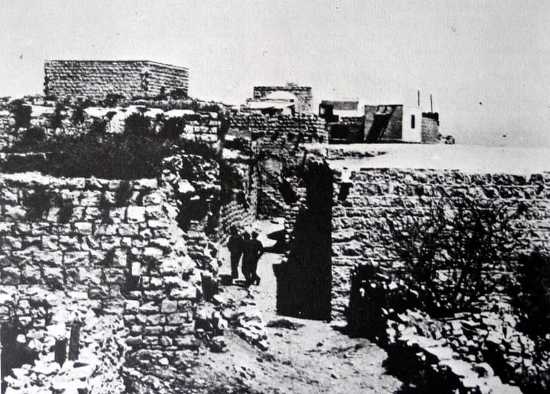
Deir Yassin sat on a hill five kilometers west of Jerusalem’s Old City, a village of stone houses and quarries whose population grew from 428 in 1931 to about 750 by 1948. It was relatively prosperous and kept workable relations with its Jewish neighbors, doing business with the nearby suburb of Givat Shaul.
On the morning of 9 April 1948, fighters of the Irgun and Lehi attacked the village. What followed was one of the war’s worst atrocities: more than a hundred Palestinian men, women, and children were killed, most shot at close range — estimates of the dead range from about one hundred to two hundred and fifty. Survivors were driven out or trucked toward Jerusalem, and the village was looted. News of the massacre spread across Palestine and became one of the most powerful accelerants of the Palestinian exodus; within weeks, ‘Deir Yassin’ had entered the language as a warning.
The village’s houses were resettled by new Jewish immigrants within months, and the Jerusalem neighborhoods of Givat Shaul and Har Nof later rose on its lands. The surviving core of the village is used to this day by the Kfar Shaul psychiatric hospital. Each April, Zochrot and Palestinian partners hold a memorial at the site, reading aloud the names of the dead.
Sources
Cited works
4- palestineremembered.com — index(opens in a new tab)https://www.palestineremembered.com/Jerusalem/Dayr-Yasin/index.html
- zochrot.org — en(opens in a new tab)https://www.zochrot.org/villages/village_details/49106/en
- palquest.org — deir yasin(opens in a new tab)https://www.palquest.org/en/place/16983/deir-yasin
- palopenmaps.org(opens in a new tab)https://palopenmaps.org/
Connected in the archive
37 connected records37 records elsewhere in the archive are linked to this one, each by a piece of evidence you can read below.
gave testimony about this village — 1 record
- Fahimi Zeidan
Evidence — From a recorded field in this archive: village: "Deir Yassin" → Deir Yassin (Jerusalem)
names this place — 14 records
One record names the other. A pointer for reading, not a claim that they belong to each other.
- The Record of 1948
Evidence — From a recorded field in this archive: The village whose April 1948 massacre accelerated the flight.
- Al-Malihaالمالِحَة
Evidence — Inferred from the text — read the evidence: Morris indicates a first wave of departure in April, in the aftermath of the massacre at Deir Yassin on 9 April, two kilometres away.
- Al-Qastalالقسطل
Evidence — Inferred from the text — read the evidence: For Palestinians, al-Qastal remains bound to the memory of al-Husayni, whose death — a day before Deir Yassin, in the same convulsed week — is often counted a turning point in the fall of Arab Jerusalem.
- Al-Sarafandسرافند الخراب
Evidence — Inferred from the text — read the evidence: Benny Morris records that the people of Sarafand al-Kharab, fearing a Jewish attack, fled on 20 April 1948 — days after a New York Times report of twelve houses blown up on the outskirts of Ramla and two neighboring villages, one of which may have been this one, and in the frightened weeks after the Deir Yassin massacre of 9 April and the Giv'ati Brigade's Operation Nachshon.
- Ein Karemعين كارم
Evidence — Inferred from the text — read the evidence: Some of its people fled after the massacre at Deir Yassin, two and a half kilometers away, in April 1948.
- Ghada Karmi
Evidence — Inferred from the text — read the evidence: …bombing of the nearby Semiramis Hotel by the Haganah on the night of 4–5 January 1948, the panic exodus of neighbors, and finally — days after the massacre at Deir Yassin — her father Hasan Karmi telling the family, "Your mother and all of you are leaving in the morning." In April 1948 the family drove to Damascus, leaving behind their maid Fatima and their dog Rex,…
- and 8 more
named in this record — 1 record
One record names the other. A pointer for reading, not a claim that they belong to each other.
- Jerusalemالقدس
Evidence — Inferred from the text — read the evidence: Deir Yassin sat on a hill five kilometers west of Jerusalem's Old City, a village of stone houses and quarries whose population grew from 428 in 1931 to about 750 by 1948.
in the same district — 21 records
Filed near each other — the same Mandate district, or the same uncommon subject tags.
- 'Allarعَلاّر
Evidence — From a recorded field in this archive: Both recorded in the Jerusalem district.
- 'Artufعَرْتُوف
Evidence — From a recorded field in this archive: Both recorded in the Jerusalem district.
- 'Islinعِسْلِين
Evidence — From a recorded field in this archive: Both recorded in the Jerusalem district.
- Al-Qabuالقبو
Evidence — From a recorded field in this archive: Both recorded in the Jerusalem district.
- Al-Walajaالولجة
Evidence — From a recorded field in this archive: Both recorded in the Jerusalem district.
- Bayt 'Itabبَيْت عِطاب
Evidence — From a recorded field in this archive: Both recorded in the Jerusalem district.
- and 15 more
Cite this page
Every claim above carries its sources — citation is the point.
- Chicago
“Deir Yassin.” Village Memory, FALASTEEN.AI. Accessed 22 August 2026. https://falasteen.ai/memory/deir-yassin.- MLA
“Deir Yassin.” Village Memory, FALASTEEN.AI, 2026, https://falasteen.ai/memory/deir-yassin. Accessed 22 August 2026.- BibTeX
@misc{falasteen-deir-yassin,
  title        = {Deir Yassin},
  howpublished = {\url{https://falasteen.ai/memory/deir-yassin}},
  organization = {FALASTEEN.AI — A Living Archive for Palestine},
  year         = {2026},
  note         = {Accessed 2026-08-22}
}