Ramla district · depopulated 1967 · 1 min read
Imwas
عمواس
Imwas, widely identified with the biblical Emmaus, survived two thousand years of empires before Israeli forces expelled its residents and bulldozed the village in June 1967. Its site lies inside Canada Park, beside the ruins of Emmaus Nicopolis.
See Imwas on the Atlas31.8420°N · 34.9927°E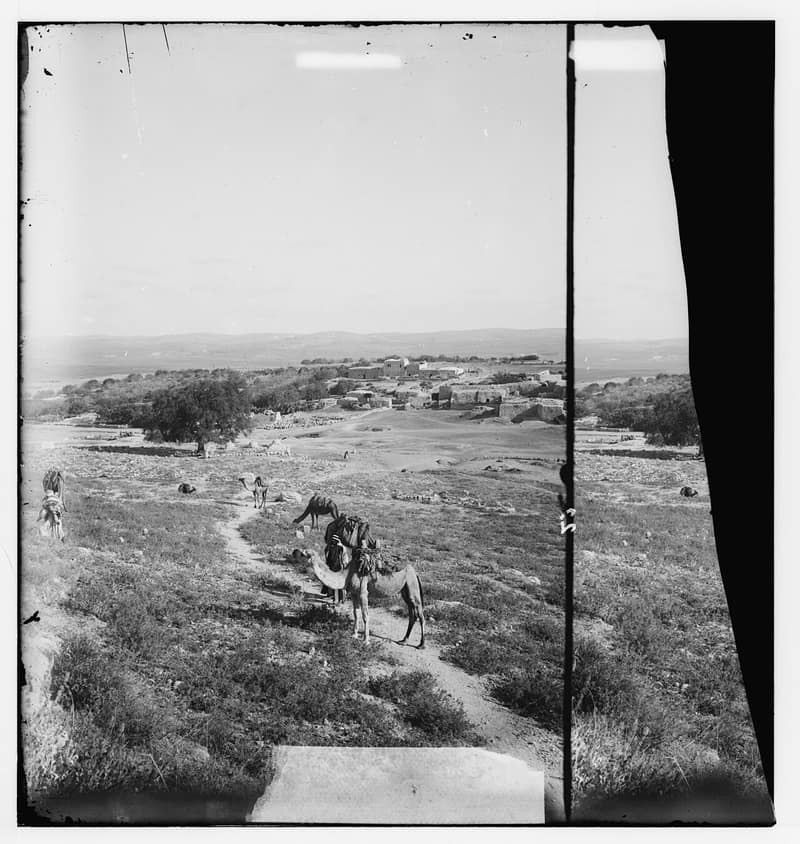
Few Palestinian villages carried as much history as Imwas. Identified by a long tradition with the Emmaus of the New Testament — the Roman city of Emmaus Nicopolis — it sat twelve kilometers southeast of Ramla in the Latrun salient, its houses built among Byzantine and Crusader stones, a Franciscan shrine, and the remains of ancient churches. Through two millennia it was ruled by Romans, caliphs, Crusaders, Ottomans, and the British; its own people farmed the valley and numbered about 1,450 in the 1945 British survey. From 1949 it lay in the Jordanian-held West Bank.
In June 1967 Israeli forces captured the salient, and Imwas shared the fate of Yalo and Bayt Nuba: its residents — Muslims and Christians alike — were driven out on foot toward Ramallah, and within weeks the village was bulldozed on orders attributed to Yitzhak Rabin. Photographs of the expulsion, columns of families carrying what they could along the road, became some of the best-known images of the 1967 displacement.
The ruins were planted over as Canada Park in the early 1970s; the archaeological site of Emmaus Nicopolis and its monastery stand adjacent, still open to pilgrims. The village’s refugees live largely in the Ramallah area, and their association, together with those of Yalo and Bayt Nuba, has marked the destruction every June since — a Nakba that came nineteen years after the first.
Sources
Cited works
3- palestineremembered.com — index(opens in a new tab)https://www.palestineremembered.com/al-Ramla/Imwas/index.html
- zochrot.org — en(opens in a new tab)https://www.zochrot.org/villages/village_details/52872/en
- en.wikipedia.org — Imwas(opens in a new tab)https://en.wikipedia.org/wiki/Imwas
Connected in the archive
28 connected records28 records elsewhere in the archive are linked to this one, each by a piece of evidence you can read below.
gave testimony about this village — 1 record
- Ahmad Abughoush
Evidence — From a recorded field in this archive: village: "Imwas, Latrun" → Imwas (Ramla)
named in this record — 6 records
One record names the other. A pointer for reading, not a claim that they belong to each other.
- Bayt Nubaبيت نوبا
Evidence — Inferred from the text — read the evidence: In June 1967 Israeli forces captured the salient, and Imwas shared the fate of Yalo and Bayt Nuba: its residents — Muslims and Christians alike — were driven out on foot toward Ramallah, and within weeks the village was bulldozed on orders attributed to Yitzhak Rabin.
- Nakba
Evidence — Inferred from the text — read the evidence: The village's refugees live largely in the Ramallah area, and their association, together with those of Yalo and Bayt Nuba, has marked the destruction every June since — a Nakba that came nineteen years after the first.
- Ramallahرام الله
Evidence — Inferred from the text — read the evidence: In June 1967 Israeli forces captured the salient, and Imwas shared the fate of Yalo and Bayt Nuba: its residents — Muslims and Christians alike — were driven out on foot toward Ramallah, and within weeks the village was bulldozed on orders attributed to Yitzhak Rabin.
- Ramleالرملة
Evidence — Inferred from the text — read the evidence: Identified by a long tradition with the Emmaus of the New Testament — the Roman city of Emmaus Nicopolis — it sat twelve kilometers southeast of Ramla in the Latrun salient, its houses built among Byzantine and Crusader stones, a Franciscan shrine, and the remains of ancient churches.
- The Nakba
Evidence — Inferred from the text — read the evidence: The village's refugees live largely in the Ramallah area, and their association, together with those of Yalo and Bayt Nuba, has marked the destruction every June since — a Nakba that came nineteen years after the first.
- Yaloيالو
Evidence — Inferred from the text — read the evidence: In June 1967 Israeli forces captured the salient, and Imwas shared the fate of Yalo and Bayt Nuba: its residents — Muslims and Christians alike — were driven out on foot toward Ramallah, and within weeks the village was bulldozed on orders attributed to Yitzhak Rabin.
names this place — 2 records
One record names the other. A pointer for reading, not a claim that they belong to each other.
- Abu Shushaأبو شوشة
Evidence — Inferred from the text — read the evidence: The tell is identified with the Old Testament city of Gezer, one of the towns listed among Thutmose III's conquests around 1469 BCE and later, by tradition, a stronghold of Solomon; it prospered under the Persians and the Greeks, was called Gazara by the Romans, and lay within the jurisdiction of Nicopolis — the site of the village of Imwas, itself destroyed in June 1967.
- Dayr Ayyubدير أيوب
Evidence — Inferred from the text — read the evidence: The eastern segment of Canada Park — planted over the ruins of Imwas, Yalo, and Bayt Nuba, destroyed in 1967 — lies across the site of Dayr Ayyub as well.
in the same district — 19 records
Filed near each other — the same Mandate district, or the same uncommon subject tags.
- Al-Magharالمَغار
Evidence — From a recorded field in this archive: Both recorded in the Ramla district.
- Al-Muzayri'aالمُزَيْرِعَة
Evidence — From a recorded field in this archive: Both recorded in the Ramla district.
- Al-Na'aniالنَعاني
Evidence — From a recorded field in this archive: Both recorded in the Ramla district.
- Al-Nabi Rubinالنبي رُوبِين
Evidence — From a recorded field in this archive: Both recorded in the Ramla district.
- Al-Qubabالقُباب
Evidence — From a recorded field in this archive: Both recorded in the Ramla district.
- Al-Qubaybaالقُبَيْبَة
Evidence — From a recorded field in this archive: Both recorded in the Ramla district.
- and 13 more
Cite this page
Every claim above carries its sources — citation is the point.
- Chicago
“Imwas.” Village Memory, FALASTEEN.AI. Accessed 22 August 2026. https://falasteen.ai/memory/imwas.- MLA
“Imwas.” Village Memory, FALASTEEN.AI, 2026, https://falasteen.ai/memory/imwas. Accessed 22 August 2026.- BibTeX
@misc{falasteen-imwas,
  title        = {Imwas},
  howpublished = {\url{https://falasteen.ai/memory/imwas}},
  organization = {FALASTEEN.AI — A Living Archive for Palestine},
  year         = {2026},
  note         = {Accessed 2026-08-22}
}