Gaza district · depopulated 1948 · 2 min read
Simsim
سمسم
Simsim, a circular village of gardens and deep wells northeast of Gaza and the hometown of a leader of the 1936 revolt, was captured and emptied by the Palmach's Negev Brigade in mid-May 1948, a day after neighboring Burayr fell. The site was obliterated; only cypress and sycamore trees mark it.
See Simsim on the Atlas31.5672°N · 34.6072°E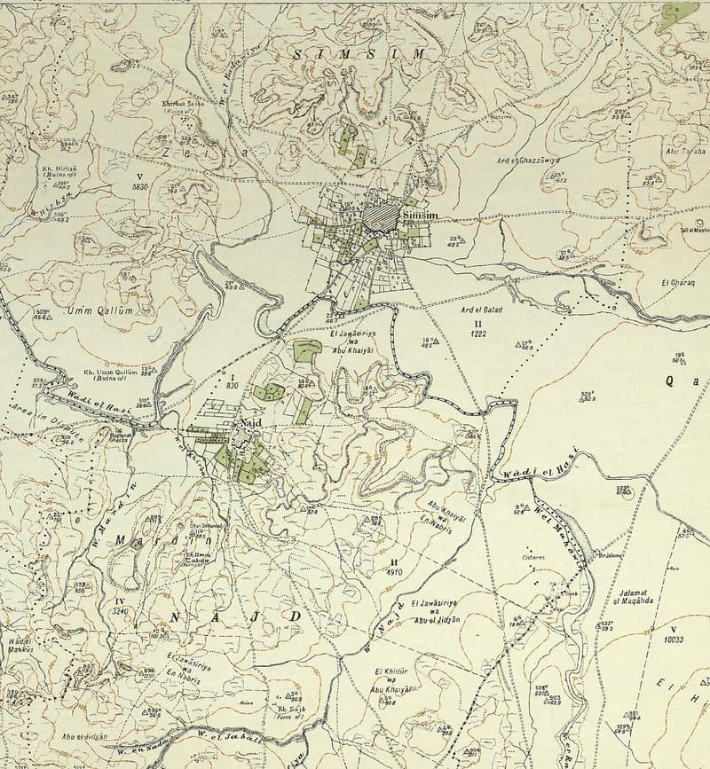
Simsim stood on flat ground on the coastal plain northeast of Gaza, ringed by hills with Wadi Simsim running along its southern edge, between the coastal highway and the parallel Gaza–Julis road. The Crusaders knew it as Semsem; in 1596 it was a village in the nahiya of Gaza with 110 people, taxed on wheat, barley, fruit trees, goats, and beehives. In the late nineteenth century it was surrounded by gardens, with a well, a pool, and an olive grove to the north. It was the hometown of al-Shaykh Sulayman Abd al-Qadir (Abu Ali), one of the leaders of the 1936 revolt against British rule. The village had a circular plan, its narrow streets radiating from a center that held the mosque and a school founded in 1934 — shared in 1947 with the children of neighboring Najd, with about 150 pupils in the mid-1940s. Its people were Muslims, its houses adobe brick. Grain, vegetables, and fruit filled its lands: in 1944/45 some 12,086 dunums were sown with cereals and 240 with citrus and bananas, irrigated from wells 35 to 40 meters deep. The 1945 survey counted 1,360 people, including 70 Jews.
The end came with the fall of its neighbor. Just before 15 May 1948 — in the wake of the occupation of Burayr on 12–13 May, according to Israeli historian Benny Morris — the Palmach’s Negev Brigade captured Simsim in one of its northward thrusts and expelled its inhabitants. A New York Times report placing the village’s capture two months later, during the fighting between the truces, is contradicted by other accounts and is generally discounted.
The settlement of Gevar’am had been established in 1942 on land that traditionally belonged to the village; Or ha-Ner was built in 1957 less than a kilometer south of the site, on the lands of Najd. The village itself has been obliterated: it can be recognized only by the cypress and sycamore trees that remain, and a pile of stones that may be the debris of a building. The site is fenced in and serves as pasture, its surrounding lands cultivated.
Sources
Cited works
3- palestineremembered.com — index(opens in a new tab)https://www.palestineremembered.com/Gaza/Simsim/index.html
- zochrot.org — en(opens in a new tab)https://www.zochrot.org/villages/village_details/49321/en
- palquest.org — simsim(opens in a new tab)https://www.palquest.org/en/place/17147/simsim
Connected in the archive
36 connected records36 records elsewhere in the archive are linked to this one, each by a piece of evidence you can read below.
gave testimony about this village — 1 record
- Jaber Ahmad Mohammad Shaban
Evidence — From a recorded field in this archive: village: "Simsim" → Simsim (Gaza)
names this place — 2 records
One record names the other. A pointer for reading, not a claim that they belong to each other.
- Gaza, by Name
Evidence — From a recorded field in this archive: A circular village of gardens and deep wells, emptied a day after Burayr. The site was obliterated; the cypress and sycamore stayed.
- Najdنجد
Evidence — Inferred from the text — read the evidence: Its people were Muslims, and its children attended school in Simsim, two kilometers to the northeast.
named in this record — 1 record
One record names the other. A pointer for reading, not a claim that they belong to each other.
- Burayrبرير
Evidence — Inferred from the text — read the evidence: Just before 15 May 1948 — in the wake of the occupation of Burayr on 12–13 May, according to Israeli historian Benny Morris — the Palmach's Negev Brigade captured Simsim in one of its northward thrusts and expelled its inhabitants.
in the same district — 32 records
Filed near each other — the same Mandate district, or the same uncommon subject tags.
- 'Iraq al-Manshiyyaعِراق المَنْشِيَّة
Evidence — From a recorded field in this archive: Both recorded in the Gaza district.
- Al-Falujaالفالوجة
Evidence — From a recorded field in this archive: Both recorded in the Gaza district.
- Al-Jiyyaالجِيَّة
Evidence — From a recorded field in this archive: Both recorded in the Gaza district.
- Al-Juraالجُورَة
Evidence — From a recorded field in this archive: Both recorded in the Gaza district.
- Al-Majdalالمجدل
Evidence — From a recorded field in this archive: Both recorded in the Gaza district.
- Al-Masmiyya al-Kabiraالمَسْمِيَّة الكَبِيرَة
Evidence — From a recorded field in this archive: Both recorded in the Gaza district.
- and 26 more
Cite this page
Every claim above carries its sources — citation is the point.
- Chicago
“Simsim.” Village Memory, FALASTEEN.AI. Accessed 22 August 2026. https://falasteen.ai/memory/simsim.- MLA
“Simsim.” Village Memory, FALASTEEN.AI, 2026, https://falasteen.ai/memory/simsim. Accessed 22 August 2026.- BibTeX
@misc{falasteen-simsim,
  title        = {Simsim},
  howpublished = {\url{https://falasteen.ai/memory/simsim}},
  organization = {FALASTEEN.AI — A Living Archive for Palestine},
  year         = {2026},
  note         = {Accessed 2026-08-22}
}