Nazareth district · depopulated 1948 · 1 min read
Saffuriyya
صفورية
Saffuriyya was the largest village of the Nazareth district — a place layered over ancient Sepphoris — until it was bombed and occupied in July 1948. Its people scattered to Nazareth and to refugee camps in Lebanon; the moshav of Zippori and an archaeological park now occupy its lands.
See Saffuriyya on the Atlas32.7531°N · 35.2792°E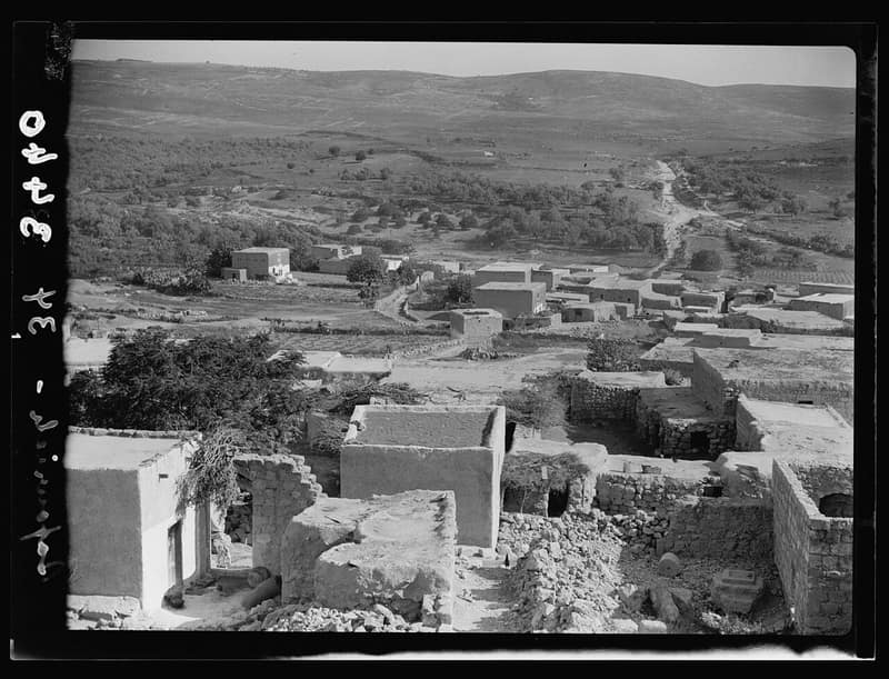
Saffuriyya lay six kilometers from Nazareth and was the largest village in the district in both population and land — more than 4,000 people on the eve of 1948, farming olives, grain, and fruit across the Bet Netofa valley. Few Palestinian villages carried such depth of time: beneath and beside it lay Sepphoris, the Greco-Roman city, and a Crusader-era fortress crowned its hill.
In the summer of 1948 the village hosted a garrison of the Arab Liberation Army. On the night of 15–16 July, during Operation Dekel, Israeli aircraft bombed Saffuriyya and ground forces moved in; the population fled — many to Nazareth, many more across the border to Lebanon, where families from Saffuriyya still live in the Miye w Miye camp. The empty village was bulldozed in the months that followed.
Today the moshav of Zippori, founded in 1949, stands on village land, and part of the site is a national archaeological park visited for its Roman mosaics. Of the Palestinian village itself, the fortress and a handful of buildings and walls remain among the orchards. Saffuriyya’s memory survived most vividly through its people — among them the family of the scholar and writer Edward Said, whose mother was born there.
Sources
Cited works
4- palestineremembered.com — index(opens in a new tab)https://www.palestineremembered.com/Nazareth/Saffuriyya/index.html
- palquest.org — saffuriyya(opens in a new tab)https://www.palquest.org/en/place/17130/saffuriyya
- palestine-studies.org(opens in a new tab)https://www.palestine-studies.org/en/node/1657654
- palopenmaps.org(opens in a new tab)https://palopenmaps.org/
Connected in the archive
7 connected records7 records elsewhere in the archive are linked to this one, each by a piece of evidence you can read below.
born here — 1 record
- Taha Muhammad Aliطه محمد علي
Evidence — From a recorded field in this archive: birthplace: "Saffuriyya, Galilee" → Saffuriyya (Nazareth)
gave testimony about this village — 1 record
- Ameen Muhammad Ali (Abu Arab)
Evidence — From a recorded field in this archive: village: "Saffuriyya, Nazareth" → Saffuriyya (Nazareth)
names this place — 2 records
One record names the other. A pointer for reading, not a claim that they belong to each other.
- The Villages of the Galilee
Evidence — From a recorded field in this archive: The largest village of the Nazareth district, built over ancient Sepphoris, bombed from the air in July 1948.
- Present Absentee
Evidence — Inferred from the text — read the evidence: Ameen Muhammad Ali of Saffuriyya — Abu Arab, whose testimony this archive keeps — told Al Jazeera in 2016 that in Israeli legal parlance he is classified as a "present absentee": present in Israel, absent from his property.
named in this record — 1 record
One record names the other. A pointer for reading, not a claim that they belong to each other.
- Nazarethالناصرة
Evidence — Inferred from the text — read the evidence: Saffuriyya lay six kilometers from Nazareth and was the largest village in the district in both population and land — more than 4,000 people on the eve of 1948, farming olives, grain, and fruit across the Bet Netofa valley.
in the same district — 2 records
Filed near each other — the same Mandate district, or the same uncommon subject tags.
- Al-Mujaydilالمجيدل
Evidence — From a recorded field in this archive: Both recorded in the Nazareth district.
- Ma'lulمعلول
Evidence — From a recorded field in this archive: Both recorded in the Nazareth district.
Cite this page
Every claim above carries its sources — citation is the point.
- Chicago
“Saffuriyya.” Village Memory, FALASTEEN.AI. Accessed 22 August 2026. https://falasteen.ai/memory/saffuriyya.- MLA
“Saffuriyya.” Village Memory, FALASTEEN.AI, 2026, https://falasteen.ai/memory/saffuriyya. Accessed 22 August 2026.- BibTeX
@misc{falasteen-saffuriyya,
  title        = {Saffuriyya},
  howpublished = {\url{https://falasteen.ai/memory/saffuriyya}},
  organization = {FALASTEEN.AI — A Living Archive for Palestine},
  year         = {2026},
  note         = {Accessed 2026-08-22}
}