Nazareth district · depopulated 1948 · 3 min read
Ma'lul
معلول
Ma'lul lay six kilometres west of Nazareth, a village of 490 Muslims and 200 Christians who had lost title to most of their land through a twenty-year legal battle with the Jewish National Fund before 1948. Israeli forces took it on 15 July 1948 during Operation Dekel and levelled the houses. Its mosque and two churches still stand inside a JNF pine forest.
See Ma'lul on the Atlas32.6956°N · 35.2395°E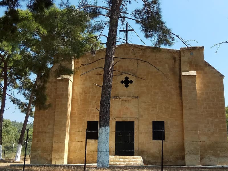
Ma’lul stood on the northern edge of Wadi al-Mujaydil, six kilometres west of Nazareth and facing the village of al-Mujaydil two kilometres to the south, with springs to its northeast and northwest and a spur road running down to the Nazareth–Haifa highway. It may occupy the site of a Roman-period village, Mahalol, which the Crusaders knew as Maula; a Roman mausoleum called locally Qasr al-Dayr stood just outside it. In 1596 it was a village of seventy-seven people in the nahiya of Tiberias. Its 690 inhabitants in 1944/45 were 490 Muslims and 200 Christians, with one mosque and two churches, Greek Orthodox and Greek Catholic. They farmed grain and olives, pressing oil by hand, and kept livestock; of 4,698 dunums, 784 were sown in cereals and 650 irrigated or planted in orchards.
By then most of that land was no longer theirs. At the start of the twentieth century the villagers were tenants of the Sursuq family of Beirut, absentee landlords who in 1921 sold all but 2,000 dunums to the Palestine Land Development Company. Since 2,000 dunums could not support the village, the company leased back 3,000 more until 1927 with an option to purchase; when the villagers tried to buy, the company said the option had lapsed and the land had passed to the Jewish National Fund, whose constitution forbade it ever to sell land again. The JNF demanded rent, sued in 1931, and in 1945 asked that the villagers be evicted. A government-brokered exchange — JNF land near Ma’lul for state land near Baysan — was blocked first by the 1937 partition plan and the 1939 White Paper and then, when renegotiated in 1946, by the fact that the Baysan land offered in return had already been settled by Zionist trespassers. No settled outcome had been reached by May 1947.
Ma’lul was one of the villages of the lower Galilee occupied during the second stage of Operation Dekel as the Israeli army closed on Nazareth. Benny Morris dates its capture to 15 July 1948, the day before Nazareth fell; a United Press report at the time put it a day earlier. Morris states that the village was completely emptied of its residents and its houses levelled. Its people were not permitted to return although most had gone no further than Nazareth and the neighbouring town of Yafa an-Naseriyye — present in the country, but classed as absentees under the Absentees’ Property Law, and so dispossessed of what land the JNF had not already taken.
The site is now covered by a pine forest planted by the Jewish National Fund and dedicated to the memory of donors, with an Israeli military base on part of it. Kfar HaHoresh, founded in 1933, lies to the east; Migdal ha-Emeq, founded in 1952, stands to the southwest on land that belonged to al-Mujaydil; Timrat was completed in 1983 on ground that is partly Ma’lul’s. The mosque and the two churches still stand among the pines, used intermittently as cowsheds by members of Kfar HaHoresh. A few graves are visible in the Muslim cemetery across from the mosque; the Christian cemetery lies inside the military compound.
Sources
Cited works
3- palquest.org — malul(opens in a new tab)https://www.palquest.org/en/place/17088/malul
- zochrot.org — en(opens in a new tab)https://www.zochrot.org/villages/village_details/49281/en
- en.wikipedia.org — Ma'alul(opens in a new tab)https://en.wikipedia.org/wiki/Ma%27alul
Connected in the archive
5 connected records5 records elsewhere in the archive are linked to this one, each by a piece of evidence you can read below.
named in this record — 4 records
One record names the other. A pointer for reading, not a claim that they belong to each other.
- Absentees' Property Law (1950)
Evidence — Inferred from the text — read the evidence: Its people were not permitted to return although most had gone no further than Nazareth and the neighbouring town of Yafa an-Naseriyye — present in the country, but classed as absentees under the Absentees' Property Law, and so dispossessed of what land the JNF had not already taken.
- Al-Mujaydilالمجيدل
Evidence — Inferred from the text — read the evidence: Ma'lul stood on the northern edge of Wadi al-Mujaydil, six kilometres west of Nazareth and facing the village of al-Mujaydil two kilometres to the south, with springs to its northeast and northwest and a spur road running down to the Nazareth–Haifa highway.
- Nazarethالناصرة
Evidence — Inferred from the text — read the evidence: Ma'lul stood on the northern edge of Wadi al-Mujaydil, six kilometres west of Nazareth and facing the village of al-Mujaydil two kilometres to the south, with springs to its northeast and northwest and a spur road running down to the Nazareth–Haifa highway.
- Tiberiasطبريا
Evidence — Inferred from the text — read the evidence: In 1596 it was a village of seventy-seven people in the nahiya of Tiberias.
in the same district — 1 record
Filed near each other — the same Mandate district, or the same uncommon subject tags.
- Saffuriyyaصفورية
Evidence — From a recorded field in this archive: Both recorded in the Nazareth district.
Cite this page
Every claim above carries its sources — citation is the point.
- Chicago
“Ma'lul.” Village Memory, FALASTEEN.AI. Accessed 22 August 2026. https://falasteen.ai/memory/malul.- MLA
“Ma'lul.” Village Memory, FALASTEEN.AI, 2026, https://falasteen.ai/memory/malul. Accessed 22 August 2026.- BibTeX
@misc{falasteen-malul,
  title        = {Ma'lul},
  howpublished = {\url{https://falasteen.ai/memory/malul}},
  organization = {FALASTEEN.AI — A Living Archive for Palestine},
  year         = {2026},
  note         = {Accessed 2026-08-22}
}