Jerusalem district · depopulated 1948 · 2 min read
Deir al-Hawa
دير الهوا
Deir al-Hawa was a tiny hamlet on a high ridge west of Jerusalem — sixty people in 1945, a mosque, and a shrine for a local sage. The Har'el Brigade captured it in October 1948 during Operation Ha-Har and it was obliterated; a Jewish National Fund park now spreads over its lands.
See Deir al-Hawa on the Atlas31.7514°N · 35.0372°E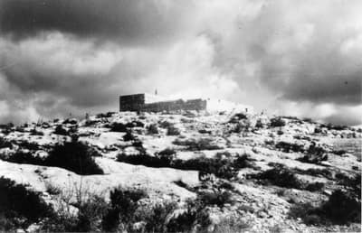
Deir al-Hawa crowned a mountaintop 650 meters above sea level, about eighteen kilometers west of Jerusalem, looking out over wide expanses in every direction. Its houses of mud and stone were crowded together along narrow alleys, built partly from stones and columns of an older ruin on the site. The villagers, all of them Muslims, worshipped at a mosque in the western part of the village and kept a shrine for Shaykh Sulayman, a local sage; two wells supplied their water. They planted grain in the valley floors and apples, olives, figs, and almonds on the slopes. The 1945 British survey counted just sixty people, in sixteen houses.
The village fell at the opening of Operation Ha-Har, the Israeli offensive into the Jerusalem hills at the end of the second truce. On the night of 18–19 October 1948 — some accounts give the following night — after taking Dayr Aban two kilometers away, the Fourth Battalion of the Har’el Brigade climbed the three hundred meters up to Deir al-Hawa; the Egyptian troops holding it withdrew under shelling. Benny Morris notes that the operation’s commander, Yigal Allon, likely made it clear that no civilian communities were to remain in the captured area. The hamlet was completely obliterated.
No Israeli settlement was built on village land; Nes Harim, founded in 1950, stands close by to the northeast. The stone rubble of houses lies mixed with ruined terrace walls, part of it bulldozed into a heap beside a later watchtower, and carob, olive, and cactus grow over the slopes. Over the lands of Deir al-Hawa and its neighbors the Jewish National Fund planted the American Independence Park, crossed by the Hubert Humphrey Parkway — a recreational forest where the village once stood.
Sources
Cited works
3- palestineremembered.com — index(opens in a new tab)https://www.palestineremembered.com/Jerusalem/Dayr-al-Hawa/index.html
- zochrot.org — en(opens in a new tab)https://www.zochrot.org/villages/village_details/50105/en
- palquest.org — dayr al hawa(opens in a new tab)https://www.palquest.org/en/place/16974/dayr-al-hawa
Connected in the archive
27 connected records27 records elsewhere in the archive are linked to this one, each by a piece of evidence you can read below.
named in this record — 2 records
One record names the other. A pointer for reading, not a claim that they belong to each other.
- Dayr Abanدَيْر آبان
Evidence — Inferred from the text — read the evidence: On the night of 18–19 October 1948 — some accounts give the following night — after taking Dayr Aban two kilometers away, the Fourth Battalion of the Har'el Brigade climbed the three hundred meters up to Deir al-Hawa; the Egyptian troops holding it withdrew under shelling.
- Jerusalemالقدس
Evidence — Inferred from the text — read the evidence: Deir al-Hawa crowned a mountaintop 650 meters above sea level, about eighteen kilometers west of Jerusalem, looking out over wide expanses in every direction.
names this place — 1 record
One record names the other. A pointer for reading, not a claim that they belong to each other.
- 'Artufعَرْتُوف
Evidence — Inferred from the text — read the evidence: Most of its people walked three miles up the slopes to the southeast, towards Dayr al-Hawa.
in the same district — 24 records
Filed near each other — the same Mandate district, or the same uncommon subject tags.
- 'Allarعَلاّر
Evidence — From a recorded field in this archive: Both recorded in the Jerusalem district.
- 'Islinعِسْلِين
Evidence — From a recorded field in this archive: Both recorded in the Jerusalem district.
- Al-Malihaالمالِحَة
Evidence — From a recorded field in this archive: Both recorded in the Jerusalem district.
- Al-Qabuالقبو
Evidence — From a recorded field in this archive: Both recorded in the Jerusalem district.
- Al-Qastalالقسطل
Evidence — From a recorded field in this archive: Both recorded in the Jerusalem district.
- Al-Walajaالولجة
Evidence — From a recorded field in this archive: Both recorded in the Jerusalem district.
- and 18 more
Cite this page
Every claim above carries its sources — citation is the point.
- Chicago
“Deir al-Hawa.” Village Memory, FALASTEEN.AI. Accessed 22 August 2026. https://falasteen.ai/memory/deir-al-hawa.- MLA
“Deir al-Hawa.” Village Memory, FALASTEEN.AI, 2026, https://falasteen.ai/memory/deir-al-hawa. Accessed 22 August 2026.- BibTeX
@misc{falasteen-deir-al-hawa,
  title        = {Deir al-Hawa},
  howpublished = {\url{https://falasteen.ai/memory/deir-al-hawa}},
  organization = {FALASTEEN.AI — A Living Archive for Palestine},
  year         = {2026},
  note         = {Accessed 2026-08-22}
}