Ramla district · depopulated 1948 · 3 min read
Bayt Nabala
بيت نبالا
Bayt Nabala looked out over the plain around Lydda from a rocky hill east of the airport, 2,310 people holding 15,051 dunums in 1944/45. On 13 July 1948 Israeli soldiers drove much of the expelled population of Lydda towards it while it was still in Arab hands; the village fell within days, during Operation Dani, and was demolished on 13 September 1948. Its people scattered to Ramallah, Deir Ammar, Rantis and the Jalazone camp.
See Bayt Nabala on the Atlas31.9856°N · 34.9567°E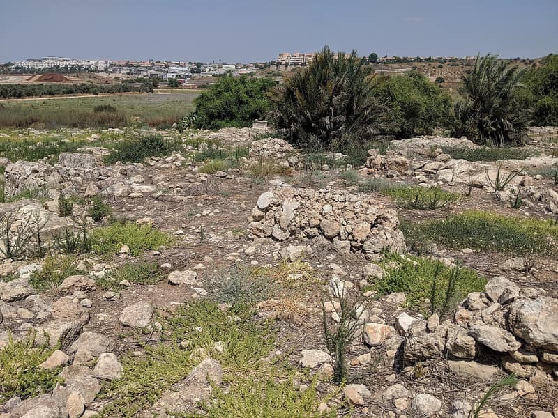
Bayt Nabala stood on a rocky hill sloping down to the southwest, overlooking the plain around Lydda and lying east of the Lydda airport, ten kilometres from Ramla. A highway to Ramla, Jaffa and the coastal cities ran to its west, and a secondary railway track linked it to the Rafah–Haifa line. In 1596 it was a village of 297 people in the nahiya of Ramla, paying tax on wheat, barley, olives and fruit as well as on goats, beehives and a press for olives or grapes. In the late nineteenth century it was a moderate-sized village at the edge of the plain, and during the Mandate the British set up a military camp nearby.
The village was laid out on a rectangular grid, its side streets running parallel to two main streets meeting at the centre, where a mosque, a number of shops and the elementary school stood. The school was founded in 1921 and had about 230 pupils by 1946–47. Most of the inhabitants were Muslims, and they built in mud and stone. They farmed grain — wheat above all — with olives, grapes, citrus and figs; agriculture was mainly rainfed but the citrus groves were watered from artesian wells. Of 15,051 dunums, 10,197 were sown in cereals, 1,733 irrigated or planted in orchards, and 226 in citrus and bananas. The population rose from 1,324 in 1922 to 1,758 in 1931 and 2,310 in 1944/45.
Bayt Nabala was named in the operational orders for Operation Dani: Israeli forces were to attack it, where the Arab Legion had stationed a second-line company of some 120 to 150 men, after the capture of Lydda and Ramla. On 13 July 1948 the people of Lydda were expelled from their city, and many were driven by Israeli soldiers towards Bayt Nabala, which was still in Arab hands. The New York Times reported Israeli commandos storming the outskirts on 11 July, Arab Legion armoured cars retaking the village on 12 July to establish shelling positions — too late to relieve Lydda — and a stiff fight on 13 July in which Israeli tanks and armoured cars took the village; a day later it was described as no man’s land but no longer a threat to Lydda or Ramla. It had certainly fallen before the second truce came into force on 18 July. Benny Morris holds that the residents had been evacuated on the orders of the Arab Legion two months earlier, on 13 May; Walid Khalidi notes that this cannot be confirmed. On 13 September 1948 Prime Minister Ben-Gurion made a formal request to the Ministerial Committee on Abandoned Property for the village’s destruction, and it was destroyed.
Kefar Truman, named for the American president, was established west of the site in 1949, and Beyt Nechemya to its south in 1950, both on village lands. The site is overgrown with grass, thorny bushes and cypress and fig trees, and on its fringes are the remains of quarries and crumbled houses, with sections of house walls still standing; the surrounding land is farmed from the settlements. The refugees of Bayt Nabala scattered across the hills to the east — to Deir Ammar, the city of Ramallah, Bayt Tillow, Rantis and the Jalazone camp north of Ramallah.
Sources
Cited works
3- palquest.org — bayt nabala(opens in a new tab)https://www.palquest.org/en/place/16944/bayt-nabala
- zochrot.org — en(opens in a new tab)https://www.zochrot.org/villages/village_details/49020/en
- en.wikipedia.org — Bayt Nabala(opens in a new tab)https://en.wikipedia.org/wiki/Bayt_Nabala
Connected in the archive
30 connected records30 records elsewhere in the archive are linked to this one, each by a piece of evidence you can read below.
named in this record — 4 records
One record names the other. A pointer for reading, not a claim that they belong to each other.
- Lyddaاللد
Evidence — Inferred from the text — read the evidence: Bayt Nabala stood on a rocky hill sloping down to the southwest, overlooking the plain around Lydda and lying east of the Lydda airport, ten kilometres from Ramla.
- Ramallahرام الله
Evidence — Inferred from the text — read the evidence: The refugees of Bayt Nabala scattered across the hills to the east — to Deir Ammar, the city of Ramallah, Bayt Tillow, Rantis and the Jalazone camp north of Ramallah.
- Ramleالرملة
Evidence — Inferred from the text — read the evidence: Bayt Nabala stood on a rocky hill sloping down to the southwest, overlooking the plain around Lydda and lying east of the Lydda airport, ten kilometres from Ramla.
- Walid Khalidiوليد خالدي
Evidence — Inferred from the text — read the evidence: Benny Morris holds that the residents had been evacuated on the orders of the Arab Legion two months earlier, on 13 May; Walid Khalidi notes that this cannot be confirmed.
names this place — 4 records
One record names the other. A pointer for reading, not a claim that they belong to each other.
- Al-Hadithaالحَدِيثَة
Evidence — Inferred from the text — read the evidence: A secondary road reached the main route between Lydda and Bayt Nabala, and other local roads joined it to the neighbouring villages.
- Dayr Tarifدَيْر طَرِيف
Evidence — Inferred from the text — read the evidence: Dayr Tarif was finally taken by 13 July, after heavy fighting around it and neighboring Bayt Nabala.
- The Expulsion of Lydda and Ramle
Evidence — Inferred from the text — read the evidence: On 13 July the residents of Lydda and Ramle — approximately 70,000 people, including refugees who had already fled to Lydda from Jaffa and its villages — were given half an hour to leave and sent east on foot toward Bayt Nabala and the Arab lines, searched and robbed of valuables at checkpoints on the way.
- The Sabr
Evidence — Inferred from the text — read the evidence: Cactus does not colonise a landscape in straight lines; as one man standing in the ruins of Bayt Nabala put it, cacti do not grow by themselves — somebody has to cultivate them.
in the same district — 22 records
Filed near each other — the same Mandate district, or the same uncommon subject tags.
- Abu Shushaأبو شوشة
Evidence — From a recorded field in this archive: Both recorded in the Ramla district.
- Al-Magharالمَغار
Evidence — From a recorded field in this archive: Both recorded in the Ramla district.
- Al-Muzayri'aالمُزَيْرِعَة
Evidence — From a recorded field in this archive: Both recorded in the Ramla district.
- Al-Na'aniالنَعاني
Evidence — From a recorded field in this archive: Both recorded in the Ramla district.
- Al-Nabi Rubinالنبي رُوبِين
Evidence — From a recorded field in this archive: Both recorded in the Ramla district.
- Al-Qubabالقُباب
Evidence — From a recorded field in this archive: Both recorded in the Ramla district.
- and 16 more
Cite this page
Every claim above carries its sources — citation is the point.
- Chicago
“Bayt Nabala.” Village Memory, FALASTEEN.AI. Accessed 22 August 2026. https://falasteen.ai/memory/bayt-nabala.- MLA
“Bayt Nabala.” Village Memory, FALASTEEN.AI, 2026, https://falasteen.ai/memory/bayt-nabala. Accessed 22 August 2026.- BibTeX
@misc{falasteen-bayt-nabala,
  title        = {Bayt Nabala},
  howpublished = {\url{https://falasteen.ai/memory/bayt-nabala}},
  organization = {FALASTEEN.AI — A Living Archive for Palestine},
  year         = {2026},
  note         = {Accessed 2026-08-22}
}