Gaza district · depopulated 1948 · 2 min read
Al-Muharraqa
المحرقة
Al-Muharraqa was a small barley-growing village east of Gaza whose lands had been waqf endowments for Jerusalem's Dome of the Rock. Raided with Kaufakha in late May 1948, its people were driven out, and in mid-August — during the second truce — Israeli forces mined and destroyed the village.
See Al-Muharraqa on the Atlas31.4670°N · 34.6113°E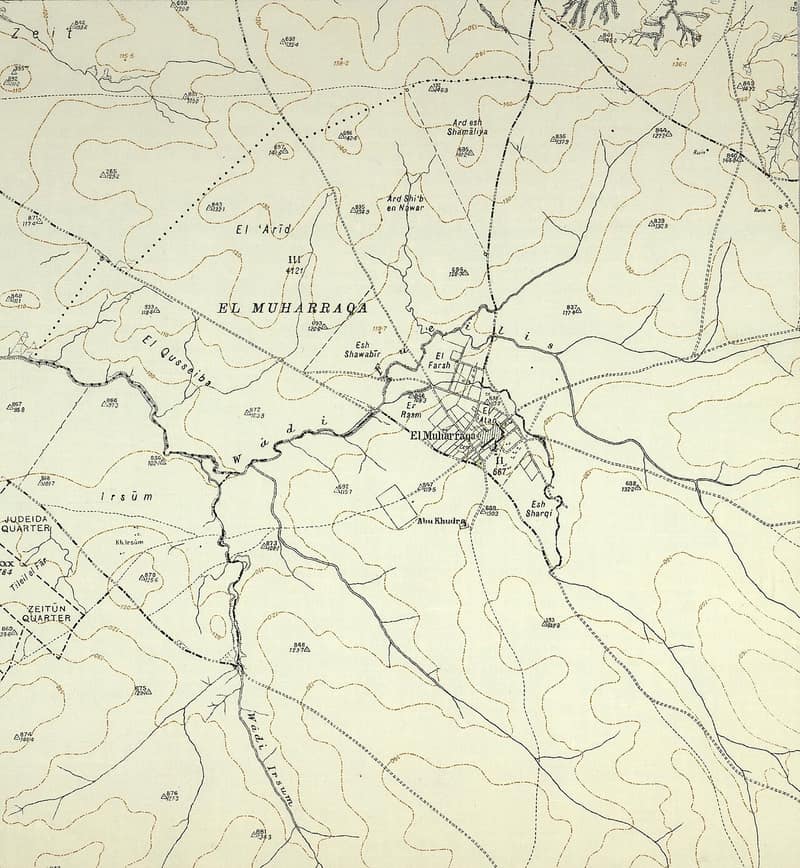
Al-Muharraqa lay on rolling terrain fourteen and a half kilometers east of Gaza, on a bend in a wadi. The place was inhabited in Byzantine times — ceramics, fragments of marble columns, and a piece of mosaic pavement have been found — and in the Mamluk period its lands and surplus harvests were dedicated as waqf to the upkeep of the Dome of the Rock in Jerusalem and the Great Mosque of Gaza; an Ottoman decree of 1535 still assigned its revenues to a Jerusalem hospital. After being abandoned in the seventeenth or eighteenth century, the village was repopulated in the late 1870s. Its mud-brick houses spread in a rectangular pattern along the roads to the highway and to neighboring Kaufakha; the mosque, a school opened in 1945 with sixty pupils, and a few small shops formed its nucleus. Water came from a slightly salty well ninety meters deep, and barley was the chief crop, with figs, grapes, and almonds besides. The 1945 survey counted 580 people, all Muslims, on 4,855 dunums, most of it public land.
On the night of 27–28 May 1948 the Palmach’s Negev Brigade raided al-Muharraqa together with Kaufakha, and a New York Times correspondent reported its official capture on 29 May. Benny Morris writes that most of the inhabitants were driven out at that time — but that the village was not thoroughly destroyed and depopulated until 16 August, when Israeli forces, formally observing the second truce, proceeded to mine and blow up the village for what were described as military reasons.
The moshav of Yakhini was built in 1950 on village land, north of the site; T’kuma, established in 1949, lies two kilometers to the west. Khalidi, visiting in 1992, found the site overgrown with thorny plants and ringed by eucalyptus: piles of rubble including the village diwan, the remnants of a mill and a well, and the dilapidated cemetery, where the fallen superstructure of a tomb was still visible.
Sources
Cited works
3- palestineremembered.com — index(opens in a new tab)https://www.palestineremembered.com/Gaza/al-Muharraqa/index.html
- zochrot.org — en(opens in a new tab)https://www.zochrot.org/villages/village_details/49290/en
- palquest.org — al muharraqa(opens in a new tab)https://www.palquest.org/en/place/16855/al-muharraqa
Connected in the archive
35 connected records35 records elsewhere in the archive are linked to this one, each by a piece of evidence you can read below.
named in this record — 1 record
One record names the other. A pointer for reading, not a claim that they belong to each other.
- Jerusalemالقدس
Evidence — Inferred from the text — read the evidence: The place was inhabited in Byzantine times — ceramics, fragments of marble columns, and a piece of mosaic pavement have been found — and in the Mamluk period its lands and surplus harvests were dedicated as waqf to the upkeep of the Dome of the Rock in Jerusalem and the Great Mosque of Gaza; an Ottoman decree of 1535 still assigned its revenues to a Jerusalem hospital.
in the same district — 34 records
Filed near each other — the same Mandate district, or the same uncommon subject tags.
- 'Iraq al-Manshiyyaعِراق المَنْشِيَّة
Evidence — From a recorded field in this archive: Both recorded in the Gaza district.
- Al-Falujaالفالوجة
Evidence — From a recorded field in this archive: Both recorded in the Gaza district.
- Al-Jiyyaالجِيَّة
Evidence — From a recorded field in this archive: Both recorded in the Gaza district.
- Al-Juraالجُورَة
Evidence — From a recorded field in this archive: Both recorded in the Gaza district.
- Al-Majdalالمجدل
Evidence — From a recorded field in this archive: Both recorded in the Gaza district.
- Al-Masmiyya al-Kabiraالمَسْمِيَّة الكَبِيرَة
Evidence — From a recorded field in this archive: Both recorded in the Gaza district.
- and 28 more
Cite this page
Every claim above carries its sources — citation is the point.
- Chicago
“Al-Muharraqa.” Village Memory, FALASTEEN.AI. Accessed 22 August 2026. https://falasteen.ai/memory/muharraqa.- MLA
“Al-Muharraqa.” Village Memory, FALASTEEN.AI, 2026, https://falasteen.ai/memory/muharraqa. Accessed 22 August 2026.- BibTeX
@misc{falasteen-muharraqa,
  title        = {Al-Muharraqa},
  howpublished = {\url{https://falasteen.ai/memory/muharraqa}},
  organization = {FALASTEEN.AI — A Living Archive for Palestine},
  year         = {2026},
  note         = {Accessed 2026-08-22}
}