Haifa district · depopulated 1948 · 2 min read
Al-Sindiyana
السنديانة
Al-Sindiyana, the 'evergreen oak' village, stood on high ground twenty-nine kilometers south of Haifa, where Napoleon fought a battle in 1799. It was depopulated on 12 May 1948, in the last days of the Mandate; its fenced site is now grazing land strewn with the rubble of its houses.
See Al-Sindiyana on the Atlas32.5568°N · 35.0023°E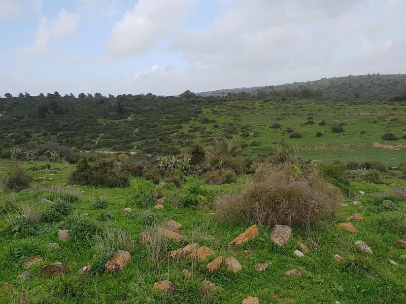
Al-Sindiyana stood on high ground twenty-nine kilometers south of Haifa, taking its name, as Victor Guérin noted in 1863, from sendian, the evergreen oak that abounded on the hills flanking it. A Samaritan stone inscription found built into a modern house there — twelve lines quoting the Shema and naming the town of Geva — may date to the early centuries of Islamic rule. On 16 March 1799, during his advance on Acre, Napoleon fought a battle just north of the village. The Survey of Western Palestine described it in 1882 as a village of moderate size with a spring below it and a cave, where the tunnel of the Caesarea aqueduct was said to have been broken into by women digging for clay. Its boys’ elementary school had 200 pupils by 1942–43, and the village drew on several wells and springs. The 1945 survey counted 1,250 people, all Muslims, on 15,172 dunums, most of it sown with cereals.
The village was depopulated on 12 May 1948, three days before the end of the British Mandate, as Haganah forces secured the coastal plain south of Haifa in the final weeks of the civil war. Like the neighboring villages of the Carmel coast corridor, its people fled or were driven out as the front passed over them; unlike Ijzim and Jaba’, which held out until July, al-Sindiyana emptied before the state was declared.
Walid Khalidi, visiting in 1992, found the site fenced in with barbed wire: scattered piles of stones, the debris of destroyed houses, visible among thorns, cactuses, and fig, olive, and palm trees, with the surrounding lands used as grazing area. Photographs from recent years show the rubble of the school and the village well still traceable in the undergrowth.
Sources
Cited works
3- palestineremembered.com — index(opens in a new tab)https://www.palestineremembered.com/Haifa/al-Sindiyana/index.html
- zochrot.org — en(opens in a new tab)https://www.zochrot.org/villages/village_details/49322/en
- palquest.org — al sindiyana(opens in a new tab)https://www.palquest.org/en/place/17148/al-sindiyana
Connected in the archive
19 connected records19 records elsewhere in the archive are linked to this one, each by a piece of evidence you can read below.
named in this record — 2 records
One record names the other. A pointer for reading, not a claim that they belong to each other.
- Haifaحيفا
Evidence — Inferred from the text — read the evidence: Al-Sindiyana stood on high ground twenty-nine kilometers south of Haifa, taking its name, as Victor Guérin noted in 1863, from sendian, the evergreen oak that abounded on the hills flanking it.
- Walid Khalidiوليد خالدي
Evidence — Inferred from the text — read the evidence: Walid Khalidi, visiting in 1992, found the site fenced in with barbed wire: scattered piles of stones, the debris of destroyed houses, visible among thorns, cactuses, and fig, olive, and palm trees, with the surrounding lands used as grazing area.
in the same district — 17 records
Filed near each other — the same Mandate district, or the same uncommon subject tags.
- Abu Shushaأبو شوشة
Evidence — From a recorded field in this archive: Both recorded in the Haifa district.
- Abu Zurayqأبو زريق
Evidence — From a recorded field in this archive: Both recorded in the Haifa district.
- Al-Kafraynالكفرين
Evidence — From a recorded field in this archive: Both recorded in the Haifa district.
- Al-Tiraالطيرة
Evidence — From a recorded field in this archive: Both recorded in the Haifa district.
- Ayn Ghazalعين غزال
Evidence — From a recorded field in this archive: Both recorded in the Haifa district.
- Ayn Hawdعين حوض
Evidence — From a recorded field in this archive: Both recorded in the Haifa district.
- and 11 more
Cite this page
Every claim above carries its sources — citation is the point.
- Chicago
“Al-Sindiyana.” Village Memory, FALASTEEN.AI. Accessed 22 August 2026. https://falasteen.ai/memory/al-sindiyana.- MLA
“Al-Sindiyana.” Village Memory, FALASTEEN.AI, 2026, https://falasteen.ai/memory/al-sindiyana. Accessed 22 August 2026.- BibTeX
@misc{falasteen-al-sindiyana,
  title        = {Al-Sindiyana},
  howpublished = {\url{https://falasteen.ai/memory/al-sindiyana}},
  organization = {FALASTEEN.AI — A Living Archive for Palestine},
  year         = {2026},
  note         = {Accessed 2026-08-22}
}