Gaza district · depopulated 1948 · 2 min read
Qastina
قسطينة
Qastina stood on the highway between al-Majdal and the Jerusalem–Jaffa road, its 890 people farming grain and citrus beside the British camp at Beer Tuvia. The Giv'ati Brigade seized it days after the first truce ended, in July 1948; Kiryat Malakhi and several settlements later rose on its lands.
See Qastina on the Atlas31.7391°N · 34.7622°E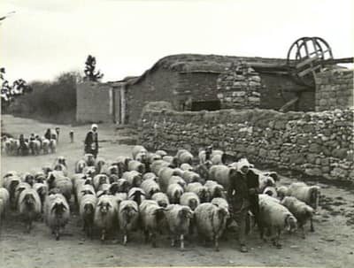
Qastina occupied a slight rise on the coastal plain some thirty-eight kilometers northeast of Gaza, on the highway between al-Majdal and the Jerusalem–Jaffa road; the British military camp of Beer Tuvia stood three kilometers to the southwest. Recorded in the Ottoman register of 1596 with 385 people, it was a village of adobe-brick houses, a mosque, and gardens watered by wells. Its elementary school, founded in 1936 and shared with neighboring Tall al-Turmus, had 161 pupils by the mid-1940s. The Muslim villagers grew grain and citrus — over 7,300 dunums of cereals in 1944/45 — raised animals and poultry, and found work in the British camp. The 1945 survey counted 890 people.
The village was taken almost as soon as the first truce of the war expired. Around 9 July 1948 the Giv’ati Brigade advanced south into Egyptian-held territory and occupied Qastina, one of at least sixteen villages seized in the ten days between the truces, whose inhabitants were all displaced. The brigade’s operational orders had called for civilians to be expelled, though by an Israeli army account the people of the area fled almost as soon as the operation began; like their neighbors in al-Masmiyya, Qastina’s people were probably driven south toward Gaza rather than east to the Hebron hills.
Jewish settlement on the village’s land had begun before its fall: Kefar Warburg was established there in 1939. After 1948 came Arugot and Kefar Achim (1949), Avigdor (1950), and the development town of Qiryat Mal’akhi — Kiryat Malakhi — in 1951. Of the village itself only debris remains: house rubble strewn across a site overgrown with bushes, tall grass, and mallow, crossed by a dirt road and shaded by eucalyptus trees.
Sources
Cited works
3- palestineremembered.com — index(opens in a new tab)https://www.palestineremembered.com/Gaza/Qastina/index.html
- zochrot.org — en(opens in a new tab)https://www.zochrot.org/villages/village_details/49453/en
- palquest.org — qastina(opens in a new tab)https://www.palquest.org/en/place/17115/qastina
Connected in the archive
34 connected records34 records elsewhere in the archive are linked to this one, each by a piece of evidence you can read below.
named in this record — 1 record
One record names the other. A pointer for reading, not a claim that they belong to each other.
- Tall al-Turmusتَلّ التُرْمُس
Evidence — Inferred from the text — read the evidence: Its elementary school, founded in 1936 and shared with neighboring Tall al-Turmus, had 161 pupils by the mid-1940s.
in the same district — 33 records
Filed near each other — the same Mandate district, or the same uncommon subject tags.
- 'Iraq al-Manshiyyaعِراق المَنْشِيَّة
Evidence — From a recorded field in this archive: Both recorded in the Gaza district.
- Al-Falujaالفالوجة
Evidence — From a recorded field in this archive: Both recorded in the Gaza district.
- Al-Jiyyaالجِيَّة
Evidence — From a recorded field in this archive: Both recorded in the Gaza district.
- Al-Juraالجُورَة
Evidence — From a recorded field in this archive: Both recorded in the Gaza district.
- Al-Majdalالمجدل
Evidence — From a recorded field in this archive: Both recorded in the Gaza district.
- Al-Masmiyya al-Kabiraالمَسْمِيَّة الكَبِيرَة
Evidence — From a recorded field in this archive: Both recorded in the Gaza district.
- and 27 more
Cite this page
Every claim above carries its sources — citation is the point.
- Chicago
“Qastina.” Village Memory, FALASTEEN.AI. Accessed 22 August 2026. https://falasteen.ai/memory/qastina.- MLA
“Qastina.” Village Memory, FALASTEEN.AI, 2026, https://falasteen.ai/memory/qastina. Accessed 22 August 2026.- BibTeX
@misc{falasteen-qastina,
  title        = {Qastina},
  howpublished = {\url{https://falasteen.ai/memory/qastina}},
  organization = {FALASTEEN.AI — A Living Archive for Palestine},
  year         = {2026},
  note         = {Accessed 2026-08-22}
}