Gaza district · depopulated 1948 · 1 min read
Hulayqat
حليقات
Hulayqat was a small village northeast of Gaza, taken in May 1948, retaken by the Egyptian army in July, and finally captured a second time in October during Operation Yoav. Its ruin, partly forested with sycamore and Christ's-thorn, lies in the corridor where the Egyptian front was cut in two.
See Hulayqat on the Atlas31.5981°N · 34.6497°E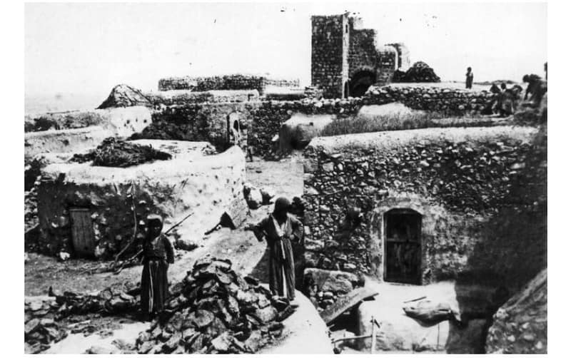
Hulayqat lay on the southern coastal plain twenty and a half kilometers northeast of Gaza, a small village on a gentle slope with a high sandy hill to its west. Its lands were rich in old remains — ruined khirbas with pieces of marble and pottery, cisterns, and a pool — but the village itself was modest: the Ottoman list of about 1870 counted fifty-five men in fourteen houses, and the Survey of Western Palestine in 1883 found cisterns, a pond, and a small garden. Like other villages of the district, its economy rested on rain-fed grain. In 1947 an oil drilling project commenced in Hulayqat, employing some 300 Arab workers. The 1945 survey counted 420 people, all Muslims, on 7,063 dunums.
The village changed hands three times in 1948. It was first captured on 13 May, during Operation Barak, the Haganah offensive to clear the villages north of Gaza before the Mandate ended, and its people were driven out. On 8 July the Egyptian army retook Hulayqat, stationing a well-fortified battalion of its 4th Brigade there, later reinforced, and some of the villagers returned to their homes. The village then sat on the Egyptian front line for three months, until the Giv’ati Brigade captured it on 19 October during Operation Yoav — the offensive that broke the ‘Separation Corridor’ and cut the Egyptian forces in the Negev in two.
Walid Khalidi, inspecting the ruin in 1992, found it partially forested with sycamore, Christ’s-thorn trees, and cactus; one of the old village roads had been paved. No Israeli settlement was established on the village site itself.
Sources
Cited works
3- palestineremembered.com — index(opens in a new tab)https://www.palestineremembered.com/Gaza/Hulayqat/index.html
- zochrot.org — en(opens in a new tab)https://www.zochrot.org/villages/village_details/49189/en
- palquest.org — hulayqat(opens in a new tab)https://www.palquest.org/en/place/17002/hulayqat
Connected in the archive
35 connected records35 records elsewhere in the archive are linked to this one, each by a piece of evidence you can read below.
named in this record — 1 record
One record names the other. A pointer for reading, not a claim that they belong to each other.
- Walid Khalidiوليد خالدي
Evidence — Inferred from the text — read the evidence: Walid Khalidi, inspecting the ruin in 1992, found it partially forested with sycamore, Christ's-thorn trees, and cactus; one of the old village roads had been paved.
in the same district — 34 records
Filed near each other — the same Mandate district, or the same uncommon subject tags.
- 'Iraq al-Manshiyyaعِراق المَنْشِيَّة
Evidence — From a recorded field in this archive: Both recorded in the Gaza district.
- Al-Falujaالفالوجة
Evidence — From a recorded field in this archive: Both recorded in the Gaza district.
- Al-Jiyyaالجِيَّة
Evidence — From a recorded field in this archive: Both recorded in the Gaza district.
- Al-Juraالجُورَة
Evidence — From a recorded field in this archive: Both recorded in the Gaza district.
- Al-Majdalالمجدل
Evidence — From a recorded field in this archive: Both recorded in the Gaza district.
- Al-Masmiyya al-Kabiraالمَسْمِيَّة الكَبِيرَة
Evidence — From a recorded field in this archive: Both recorded in the Gaza district.
- and 28 more
Cite this page
Every claim above carries its sources — citation is the point.
- Chicago
“Hulayqat.” Village Memory, FALASTEEN.AI. Accessed 22 August 2026. https://falasteen.ai/memory/hulayqat.- MLA
“Hulayqat.” Village Memory, FALASTEEN.AI, 2026, https://falasteen.ai/memory/hulayqat. Accessed 22 August 2026.- BibTeX
@misc{falasteen-hulayqat,
  title        = {Hulayqat},
  howpublished = {\url{https://falasteen.ai/memory/hulayqat}},
  organization = {FALASTEEN.AI — A Living Archive for Palestine},
  year         = {2026},
  note         = {Accessed 2026-08-22}
}