Gaza district · depopulated 1948 · 2 min read
Hamama
حمامة
Hamama — 'dove' in Arabic — was one of the largest villages of the Gaza district, over five thousand people spread in a star pattern along the roads north of Gaza. Harassed from neighboring Nitzanim through early 1948 and swollen with refugees, it was occupied in late October 1948 during Operation Yoav; no trace of its houses remains.
See Hamama on the Atlas31.6912°N · 34.5900°E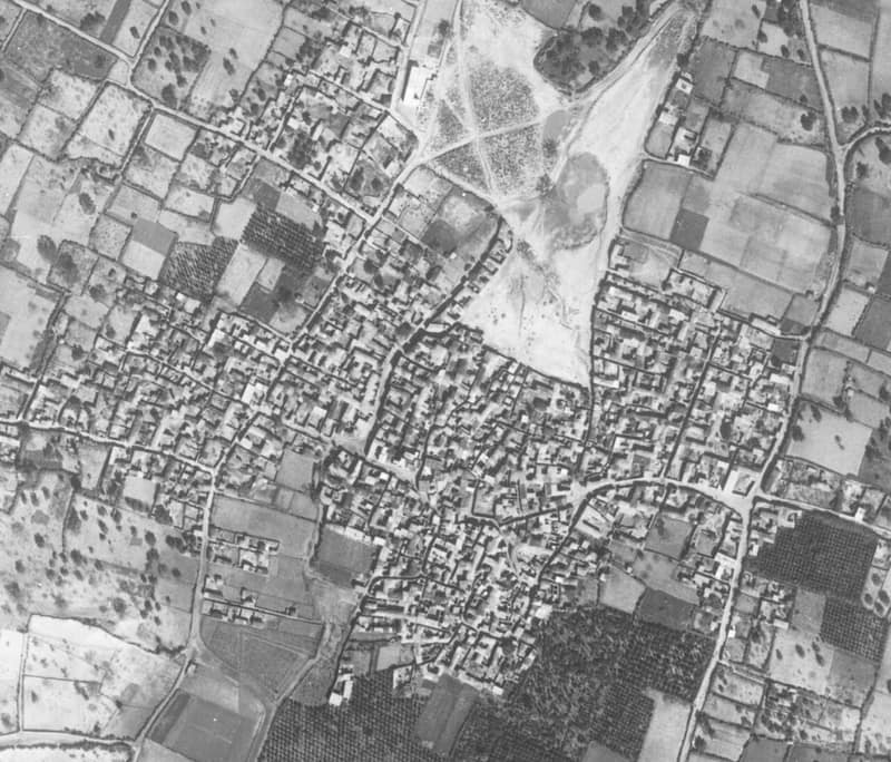
Hamama stood on flat coastal-plain land twenty-four kilometers north of Gaza, about two kilometers from the sea, between two long sand dunes, with the coastal highway and railway just to its east. Its name — ‘dove’ — matched its antiquity: it was built over Tall Mishqafa, identified with the Byzantine town of Peleia, which means the same. The village grew in a star pattern along the roads to neighboring settlements; it had a mosque, a boys’ school from 1921 and a girls’ school from 1946, and a village council. Its people grew grain, citrus, apricots, almonds, figs, olives, and melons, and planted trees against the encroaching sand. The 1945 survey counted 5,070 people — 5,010 of them Arabs, nearly all Muslims — making Hamama one of the largest villages of the Gaza district in both land and population.
The war reached Hamama early. In January 1948 villagers working the fields between Hamama and Isdud were shot at from nearby Nitzanim, leaving fifteen wounded; days later another villager was killed, and in February people waiting for the bus on the main road were fired on. By the autumn the village was crowded with refugees from earlier offensives. According to Benny Morris, Hamama was occupied in the third stage of Operation Yoav, on 28 October 1948, as Isdud, five kilometers north, fell to Israeli forces and the Egyptian army withdrew down the coast.
Settlements had already taken root on the village’s lands before its fall — Nitzanim, founded in 1943 — and others followed: Nitzanim–Kefar ha-No’ar in 1949, Beit Ezra in 1950, and the Eshkolot farm in the 1950s. Of Hamama itself, nothing stands: no trace of its houses or landmarks survives. The rubble of the demolished village was pushed into heaps at the northern edge of the site, and the rest is wild vegetation — tall grasses, weeds, bushes, and cactuses.
Sources
Cited works
3- palestineremembered.com — index(opens in a new tab)https://www.palestineremembered.com/Gaza/Hamama/index.html
- zochrot.org — en(opens in a new tab)https://www.zochrot.org/villages/village_details/49181/en
- palquest.org — hamama(opens in a new tab)https://www.palquest.org/en/place/16995/hamama
Connected in the archive
34 connected records34 records elsewhere in the archive are linked to this one, each by a piece of evidence you can read below.
names this place — 1 record
One record names the other. A pointer for reading, not a claim that they belong to each other.
- Al-Juraالجُورَة
Evidence — Inferred from the text — read the evidence: The Syrian Sufi traveler Mustafa al-Bakri al-Siddiqi recorded visiting it in the middle of the eighteenth century before going on to Hamama.
in the same district — 33 records
Filed near each other — the same Mandate district, or the same uncommon subject tags.
- 'Iraq al-Manshiyyaعِراق المَنْشِيَّة
Evidence — From a recorded field in this archive: Both recorded in the Gaza district.
- Al-Falujaالفالوجة
Evidence — From a recorded field in this archive: Both recorded in the Gaza district.
- Al-Jiyyaالجِيَّة
Evidence — From a recorded field in this archive: Both recorded in the Gaza district.
- Al-Majdalالمجدل
Evidence — From a recorded field in this archive: Both recorded in the Gaza district.
- Al-Masmiyya al-Kabiraالمَسْمِيَّة الكَبِيرَة
Evidence — From a recorded field in this archive: Both recorded in the Gaza district.
- Al-Masmiyya al-Saghiraالمسمية الصغيرة
Evidence — From a recorded field in this archive: Both recorded in the Gaza district.
- and 27 more
Cite this page
Every claim above carries its sources — citation is the point.
- Chicago
“Hamama.” Village Memory, FALASTEEN.AI. Accessed 22 August 2026. https://falasteen.ai/memory/hamama.- MLA
“Hamama.” Village Memory, FALASTEEN.AI, 2026, https://falasteen.ai/memory/hamama. Accessed 22 August 2026.- BibTeX
@misc{falasteen-hamama,
  title        = {Hamama},
  howpublished = {\url{https://falasteen.ai/memory/hamama}},
  organization = {FALASTEEN.AI — A Living Archive for Palestine},
  year         = {2026},
  note         = {Accessed 2026-08-22}
}