Hebron district · depopulated 1948 · 1 min read
Bayt Jibrin
بيت جبرين
Bayt Jibrin, the Roman city of Eleutheropolis, dominated the crossroads of the southern hills until October 1948, when it was captured during Operation Yoav. Its people fled to the Hebron hills and refugee camps such as al-Fawwar and Aida; kibbutz Beit Guvrin rose on its lands.
See Bayt Jibrin on the Atlas31.6053°N · 34.8983°E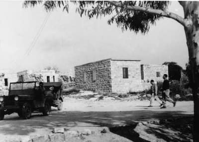
Bayt Jibrin stood twenty-one kilometers northwest of Hebron, in the western foothills where the road from the coast climbs toward the mountains. It was an ancient place: the Romans refounded it as Eleutheropolis, “city of the free,” and the soft chalk beneath it was honeycombed over the centuries into bell-shaped caves — the same cave network later inscribed, with nearby Maresha, as a UNESCO World Heritage Site. Its people farmed the broad valley of Wadi Bayt Jibrin and wove and traded at the junction of roads to Hebron, Ramla, and al-Faluja; the 1945 British survey counted about 2,400 residents.
The end came in the autumn offensive of 1948. On 27 October, during Operation Yoav, Givati Brigade units took the town after aerial and artillery attack, and its people fled or were driven east into the Hebron hills. Many ended up a few kilometers from home in the refugee camps that still exist — al-Fawwar and al-‘Arroub near Hebron, and Aida beside Bethlehem — close enough to see the hills they left.
Kibbutz Beit Guvrin was established on the village lands in 1949, and the surrounding caves became a national park. Of the town itself, a few houses, a shrine, and the cemetery remain among the ruins; for the camp communities, Bayt Jibrin remains the measure of how short the distance into exile can be.
Sources
Cited works
3- palestineremembered.com — index(opens in a new tab)https://www.palestineremembered.com/Hebron/Bayt-Jibrin/index.html
- zochrot.org — en(opens in a new tab)https://www.zochrot.org/villages/village_details/49055/en
- palquest.org — bayt jibrin(opens in a new tab)https://www.palquest.org/en/place/16940/bayt-jibrin
Connected in the archive
21 connected records21 records elsewhere in the archive are linked to this one, each by a piece of evidence you can read below.
names this place — 19 records
One record names the other. A pointer for reading, not a claim that they belong to each other.
- 'Ajjurعَجُّور
Evidence — Inferred from the text — read the evidence: 'Ajjur spread over hilly ground in the western foothills of the Hebron mountains, about 24 kilometres northwest of Hebron at an average elevation of 275 metres, linked by a secondary road to the highway between Bayt Jibrin and the Jaffa–Jerusalem road.
- 'Allarعَلاّر
Evidence — Inferred from the text — read the evidence: A secondary road connected it to the Bayt Jibrin–Bethlehem road, a kilometre to the south.
- 'Iraq al-Manshiyyaعِراق المَنْشِيَّة
Evidence — Inferred from the text — read the evidence: 'Iraq al-Manshiyya stood thirty-two kilometers from Gaza in a country of rolling hills where the coastal plain merges into the foothills of the Hebron mountains, bounded on the west by Wadi Fattala and lying on the south side of the highway between al-Faluja to the northwest and Bayt Jibrin to the east.
- 'Islinعِسْلِين
Evidence — Inferred from the text — read the evidence: It lay about a kilometre west of the highway between Bayt Jibrin and the Jaffa–Jerusalem road, with dirt paths to its neighbours.
- Al-Dawayimaالدوايمة
Evidence — Inferred from the text — read the evidence: An elementary school opened in 1937. From 1944 a weekly Friday market was held on the threshing floor, drawing traders from Bayt Jibrin, Hebron and Gaza; the villagers called it suq al-barrayn, the market of the two terrains, because it joined the produce of the hills to that of the plain.
- Al-Qabuالقبو
Evidence — Inferred from the text — read the evidence: Al-Qabu crowned a steep mountain west of Jerusalem, not far from Ayn Karim, with a secondary road linking it to the Bayt Jibrin–Jerusalem highway.
- and 13 more
named in this record — 1 record
One record names the other. A pointer for reading, not a claim that they belong to each other.
- Hebronالخليل
Evidence — Inferred from the text — read the evidence: Bayt Jibrin stood twenty-one kilometers northwest of Hebron, in the western foothills where the road from the coast climbs toward the mountains.
in the same district — 1 record
Filed near each other — the same Mandate district, or the same uncommon subject tags.
- Dayr al-Dubbanدَيْر الدُبّان
Evidence — From a recorded field in this archive: Both recorded in the Hebron district.
Cite this page
Every claim above carries its sources — citation is the point.
- Chicago
“Bayt Jibrin.” Village Memory, FALASTEEN.AI. Accessed 22 August 2026. https://falasteen.ai/memory/bayt-jibrin.- MLA
“Bayt Jibrin.” Village Memory, FALASTEEN.AI, 2026, https://falasteen.ai/memory/bayt-jibrin. Accessed 22 August 2026.- BibTeX
@misc{falasteen-bayt-jibrin,
  title        = {Bayt Jibrin},
  howpublished = {\url{https://falasteen.ai/memory/bayt-jibrin}},
  organization = {FALASTEEN.AI — A Living Archive for Palestine},
  year         = {2026},
  note         = {Accessed 2026-08-22}
}